username:pyty Royalty Free Vector Images (3,773)
Page 70 of 76

Map of Central Asia region with highlighted Kazakhstan, Kyrgyzstan, Tajikistan, Turkmenistan and Uzbekistan. Flat grey map with country white borders
VectorUsername
pytyResolution
5000x3750pxMap of Central Asia region with highlighted Kazakhstan, Kyrgyzstan, Tajikistan, Turkmenistan and Uzbekistan. Flat grey map with country white borders


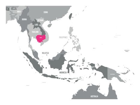
Vector map of Cambodia. Pink highlighted in Southeast Asia region
VectorUsername
pytyResolution
5000x3750pxVector map of Cambodia. Pink highlighted in Southeast Asia region
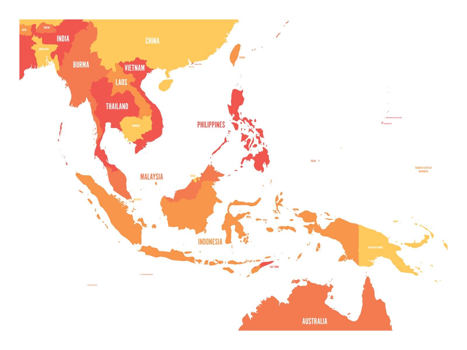
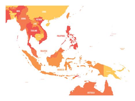
Map of Southeast Asia. Vector map in shades of orange
VectorUsername
pytyResolution
5000x3750pxMap of Southeast Asia. Vector map in shades of orange
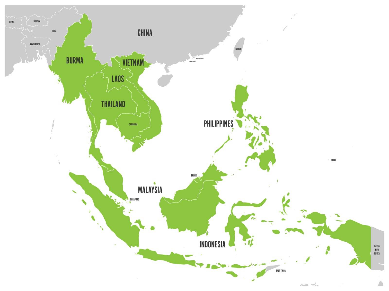
ASEAN Economic Community, AEC, map. Grey map with green highlighted member countries, Southeast Asia. Vector illustration
VectorUsername
pytyResolution
5000x3750pxASEAN Economic Community, AEC, map. Grey map with green highlighted member countries, Southeast Asia. Vector illustration


Political map of western, southern and eastern Asia in grey. Modern style simple flat vector illustration
VectorUsername
pytyResolution
5000x3333pxPolitical map of western, southern and eastern Asia in grey. Modern style simple flat vector illustration


Blank political map of western, southern and eastern Asia. Thin black outline borders on light grey background. Vector illustration
VectorUsername
pytyResolution
5000x3333pxBlank political map of western, southern and eastern Asia. Thin black outline borders on light grey background. Vector illustration


China blue marked in political map of Southern Asia. Vector illustration
VectorUsername
pytyResolution
5000x3333pxChina blue marked in political map of Southern Asia. Vector illustration


India blue marked in political map of Southern Asia. Vector illustration
VectorUsername
pytyResolution
5000x3333pxIndia blue marked in political map of Southern Asia. Vector illustration


Arab World states political map with higlighted 22 arabic-speaking countries of the Arab League. Northern Africa and Middle East region. Vector illustration
VectorUsername
pytyResolution
5000x3358pxArab World states political map with higlighted 22 arabic-speaking countries of the Arab League. Northern Africa and Middle East region. Vector illustration


Arab World states political map with orange higlighted 22 arabic-speaking countries of the Arab League. Northern Africa and Middle East region. Vector map with blue water and yellow lands
VectorUsername
pytyResolution
5000x3358pxArab World states political map with orange higlighted 22 arabic-speaking countries of the Arab League. Northern Africa and Middle East region. Vector map with blue water and yellow lands


United Kingdom, UK, of Great Britain and Northern Ireland map. Divided to four countries - England, Wales, Scotland and NI. Simple flat vector illustration
VectorUsername
pytyResolution
3359x5000pxUnited Kingdom, UK, of Great Britain and Northern Ireland map. Divided to four countries - England, Wales, Scotland and NI. Simple flat vector illustration


United Kingdom, aka UK, of Great Britain and Northern Ireland hand-drawn blank map. Divided to four countries in different colors - England, Wales, Scotland and NI. Simple flat vector illustration
VectorUsername
pytyResolution
3388x5000pxUnited Kingdom, aka UK, of Great Britain and Northern Ireland hand-drawn blank map. Divided to four countries in different colors - England, Wales, Scotland and NI. Simple flat vector illustration


Outline map of France divided into 13 administrative metropolitan regions, since 2016. Four shades of green. Vector illustration
VectorUsername
pytyResolution
4976x5000pxOutline map of France divided into 13 administrative metropolitan regions, since 2016. Four shades of green. Vector illustration


Simplified hand-drawn blank map of United Kingdom of Great Britain and Northern Ireland, UK. Divided to four countries with England red highlighted. Simple flat vector illustration
VectorUsername
pytyResolution
3388x5000pxSimplified hand-drawn blank map of United Kingdom of Great Britain and Northern Ireland, UK. Divided to four countries with England red highlighted. Simple flat vector illustration


Blue map pointer with dropped shadow on white background. EPS10 vector illustration
VectorUsername
pytyResolution
5000x5000pxBlue map pointer with dropped shadow on white background. EPS10 vector illustration


Blue map pointer with world map silhouette icon. Vector illustration with dropped shadow
VectorUsername
pytyResolution
5000x5000pxBlue map pointer with world map silhouette icon. Vector illustration with dropped shadow


Blue map pointer with dropped shadow on white background. EPS10 vector illustration
VectorUsername
pytyResolution
5000x5000pxBlue map pointer with dropped shadow on white background. EPS10 vector illustration


Map of United Nation with orange highlighted member states. UN is an intergovernmental organization of international co-operation. EPS10 vector illustration
VectorUsername
pytyResolution
5000x3750pxMap of United Nation with orange highlighted member states. UN is an intergovernmental organization of international co-operation. EPS10 vector illustration


Map of Comprehensive and Progressive Agreement for Trans-Pacific Partnership, CPTPP or TPP11. Yellow highlighted member states. Vector illustration
VectorUsername
pytyResolution
5000x3696pxMap of Comprehensive and Progressive Agreement for Trans-Pacific Partnership, CPTPP or TPP11. Yellow highlighted member states. Vector illustration


Group of Seven countries, G7, highlighted in the World map. Vector illustration
VectorUsername
pytyResolution
5000x3750pxGroup of Seven countries, G7, highlighted in the World map. Vector illustration


North Atlantic Treaty Organization, NATO, member countries highlighted by blue in world political map. 29 member states since June 2017
VectorUsername
pytyResolution
5000x3684pxNorth Atlantic Treaty Organization, NATO, member countries highlighted by blue in world political map. 29 member states since June 2017


Arab World states. Political map of 22 arabic-speaking countries of the Arab League. Northern Africa and Middle East region. Vector illustration
VectorUsername
pytyResolution
5000x3387pxArab World states. Political map of 22 arabic-speaking countries of the Arab League. Northern Africa and Middle East region. Vector illustration


Map of Czech Republic with administrative regions
VectorUsername
pytyResolution
5000x3545pxMap of Czech Republic with administrative regions


France map silhouette mosaic of cogs and gears
VectorUsername
pytyResolution
5000x5000pxFrance map silhouette mosaic of cogs and gears


European Union territory blue silhouette. Map of EU. Vector illustration
VectorUsername
pytyResolution
5000x5000pxEuropean Union territory blue silhouette. Map of EU. Vector illustration


European Union Enlargements
VectorUsername
pytyResolution
5000x5000pxEuropean Union Enlargements


European Union territory grey silhouette. Map of EU. Vector illustration
VectorUsername
pytyResolution
5000x5000pxEuropean Union territory grey silhouette. Map of EU. Vector illustration


European Union territory. Blue gradient silhouette isolated on white background. Map of EU. Vector illustration
VectorUsername
pytyResolution
5000x4878pxEuropean Union territory. Blue gradient silhouette isolated on white background. Map of EU. Vector illustration


European Union territory black silhouette isolated on white background. Map of EU. Vector illustration
VectorUsername
pytyResolution
5000x4878pxEuropean Union territory black silhouette isolated on white background. Map of EU. Vector illustration

Vector map of EU, European Union.
VectorUsername
pytyResolution
5000x5000pxVector map of EU, European Union.


Brexit theme map - European Union with highlighted United Kingdom
VectorUsername
pytyResolution
5000x5000pxBrexit theme map - European Union with highlighted United Kingdom


Political map of Europe in four shades of violet on white background. Vector illustration
VectorUsername
pytyResolution
4994x5000pxPolitical map of Europe in four shades of violet on white background. Vector illustration


Political map of Europe in four shades of yellow on white background. Vector illustration
VectorUsername
pytyResolution
4994x5000pxPolitical map of Europe in four shades of yellow on white background. Vector illustration


Colorful blank map of Europe
VectorUsername
pytyResolution
5000x5000pxColorful blank map of Europe


Colorful map of Europe
VectorUsername
pytyResolution
5000x5000pxColorful map of Europe


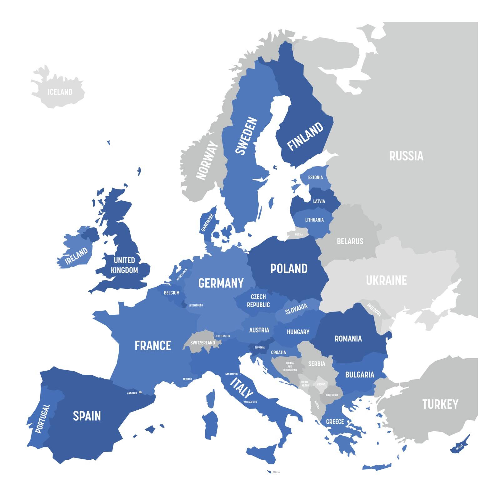
Europe map with names of sovereign countries
VectorUsername
pytyResolution
5000x5000pxEurope map with names of sovereign countries


Vector map of Europe
VectorUsername
pytyResolution
5000x5000pxVector map of Europe


Political map of Europe continent in four shades of maroon with white country name labels and isolated on white background. Vector illustration
VectorUsername
pytyResolution
5000x2500pxPolitical map of Europe continent in four shades of maroon with white country name labels and isolated on white background. Vector illustration


Blank political map of Europe continent in four shades of orange. Vector illustration
VectorUsername
pytyResolution
5000x5000pxBlank political map of Europe continent in four shades of orange. Vector illustration


Political map of Europe. European ministates included. Flat map on white background. Colorful vector illustration
VectorUsername
pytyResolution
5000x5000pxPolitical map of Europe. European ministates included. Flat map on white background. Colorful vector illustration


Member states of the British Commonwealth pink highlighted in the world map. Vector illustration
VectorUsername
pytyResolution
5000x3750pxMember states of the British Commonwealth pink highlighted in the world map. Vector illustration


Member states of the British Commonwealth orange highlighted in the world map. Vector illustration
VectorUsername
pytyResolution
5000x3750pxMember states of the British Commonwealth orange highlighted in the world map. Vector illustration


Member states of the British Commonwealth blue highlighted in the world map. Vector illustration
VectorUsername
pytyResolution
5000x3750pxMember states of the British Commonwealth blue highlighted in the world map. Vector illustration


Member states of the British Commonwealth green highlighted in the world map. Vector illustration
VectorUsername
pytyResolution
5000x3750pxMember states of the British Commonwealth green highlighted in the world map. Vector illustration


Member states of the British Commonwealth blue highlighted in the world map. Vector illustration
VectorUsername
pytyResolution
5000x3750pxMember states of the British Commonwealth blue highlighted in the world map. Vector illustration


Australia map with states and territories
VectorUsername
pytyResolution
5000x3750pxAustralia map with states and territories


Australia map with states and territories
VectorUsername
pytyResolution
5000x3750pxAustralia map with states and territories

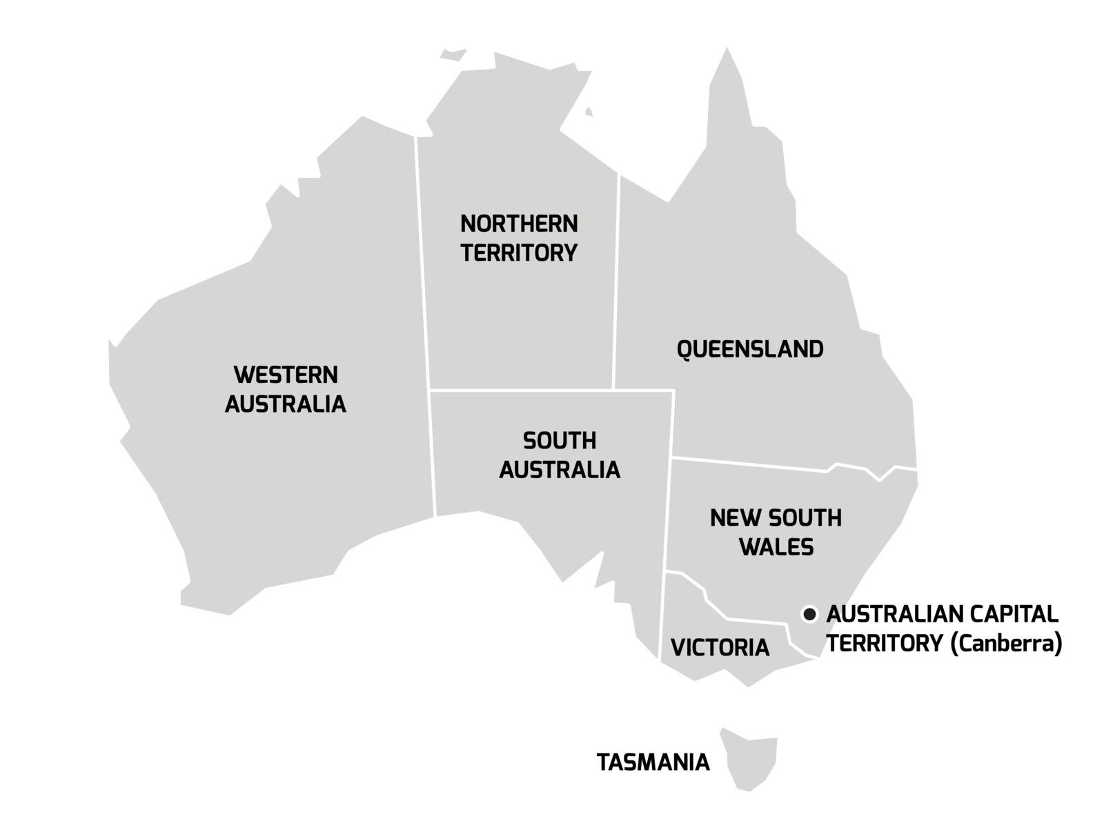
Australia map with states and territories
VectorUsername
pytyResolution
5000x3750pxAustralia map with states and territories


Simplified map of Australia divided into states and territories. Blue flat map with white borders and labels
VectorUsername
pytyResolution
5000x3750pxSimplified map of Australia divided into states and territories. Blue flat map with white borders and labels


Australia map with states and territories
VectorUsername
pytyResolution
5000x3750pxAustralia map with states and territories
